Millions live in ‘urban heat islands.’ Are you one of them?
(NEXSTAR) – Does it feel hotter on your block than the temperature predicted by your local TV meteorologist? The “urban heat island” effect may be to blame.
“Urban heat islands” can make heat waves feel even hotter, recording temperatures that are several degrees higher than the surrounding area.
It comes down to the way cities and neighborhoods are designed. The temperature on your block is influenced by everything from the number of trees on the street to the color of the pavement. When trees and vegetation (which absorb heat) are replaced by buildings and roads (which can radiate heat), it feels hotter.
“The heat island effect can result in significant temperature differences between rural and urban areas,” explains the Environmental Protection Agency.
Climate Central, an organization of scientists and journalists focused on studying the impacts of climate change, broke down 65 cities into Census blocks to determine which neighborhoods suffer from the worst urban heat effects.
Six cities had more than 1 million people living under an urban heat island effect over 8 degrees, they found. That means for millions of residents of New York, Los Angeles, Houston, Chicago, San Antonio and Dallas, “on a day when temperatures in a park outside the city are 90°F, it feels like 98°F or higher,” the report explains.
The urban heat island effect can still be at play in smaller and mid-size cities. More than 80% of the population in the following cities experiences 8 degrees (or more heat) because of their built environment:
| City | Population with UHI index of 8°F or higher | Percent of total population |
|---|---|---|
| Newark, N.J. | 302,784 | 97% |
| Ft. Myers, Fla. | 82,959 | 96% |
| West Palm Beach, Fla. | 110,699 | 94% |
| Detroit, Mich. | 571,884 | 89% |
| San Antonio, Texas | 1,267,961 | 88% |
| Norfolk, Va. | 208,856 | 88% |
| Tampa, Fla. | 336,340 | 87% |
| Spokane, Wa. | 198,502 | 87% |
| Tulsa, Okla. | 344,755 | 83% |
| New York, N.Y. | 7,267,312 | 83% |
| Dayton, Ohio | 113,369 | 82% |
| Dallas, Texas | 1,061,649 | 81% |
Maps created by the researchers for 65 cities can help you determine how bad the urban heat effect is in your neighborhood.
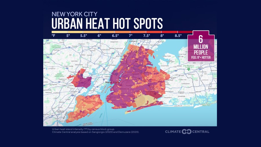
Take New York City, for example. The map of hot spots around New York shows lots of neighborhoods shaded in dark red and purple, with relief only to be found in the park-filled parts of Queens and on Staten Island.

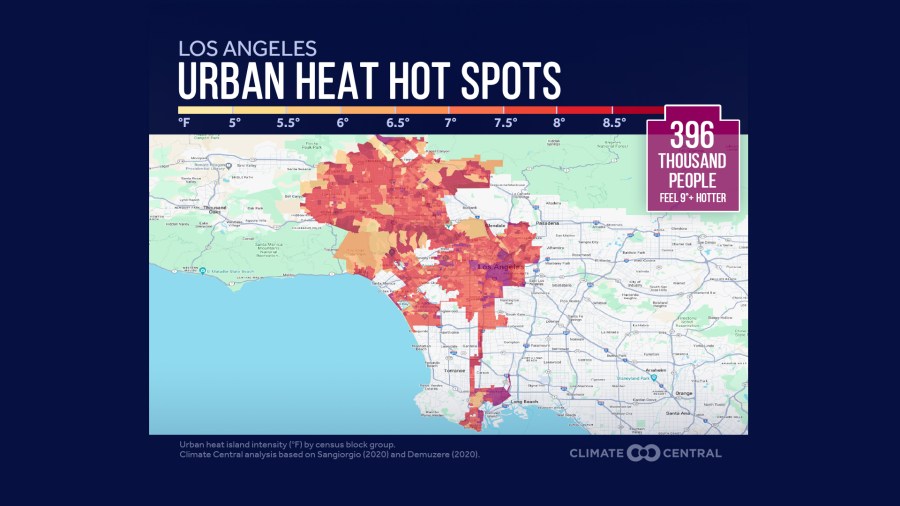
Meanwhile, the map of Los Angeles looks different. Downtown Los Angeles suffers the worst of it, but a much larger geographic area has an urban heat impact between 7 and 8 degrees.
There are just a few neighborhoods where you can find an urban heat effect less than 7 degrees.

You can explore the different urban heat islands of all the U.S. cities analyzed here.
The researchers also named a number of solutions — both short-term and long-term — to the urban heat problem. Planting trees can help, especially as those trees mature and grow larger to increase shade. Roof materials that reflect heat, as well as rooftop gardens, can cool things down in dense neighborhoods.
One of the hottest parts of any city is dark pavement that’s been soaking up the sun. Asphalt and concrete can even radiate heat after the sun goes down, keeping a neighborhood from cooling down at night. The EPA suggests looking into “cool pavement” technology as a solution.
Copyright 2023 Nexstar Media Inc. All rights reserved. This material may not be published, broadcast, rewritten, or redistributed.

